ALL VOLCANOES OF THE NORTHERN KURIL
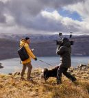
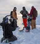
Leonid spent 38 years of life among the Kuril volcanoes and his fascinating stories can be heard endlessly. Here, short and to the point, you can read his story of the Northern Kuril Islands volcanoes activity.
Since 1982 Leonid Kotenko had been spending all his time in the Kuril Islands. Since 1998 he had been working as a leading engineer at the Institute of Volcanology and Seismology of the Far-Eastern Division of the Russian Academy of Science. Tatiana, his wife, joined him and started working at IVOLCS in 2001. He is interested in tourism, photography and the history of the Far East…

We have prepared a new program for you: "KURIL ISLANDS SAILING ADVENTURE"!
Leonid:
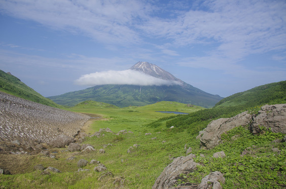
"We and the Volcano Institute are responsible for the Islands of the North-Kuril Urban District. The Urban District occupies half of the length of the Kuril range. That is 600 km - from Atlasov Island in the North to Ketoy. Accordingly, there are a lot of volcanoes in this area. The first, the most northern and the largest volcano is Alaid, that is located on Atlasov Island.

It rises above sea level by 2339 m, goes from the west, northwestern side from 1.5 to 2.5 km, so it grew from the bottom of the sea. Of course, Alaid is a very beautiful volcano, it has 29 side craters, and one of the side craters, the 30th, went into a separate volcano, Taketomi.

Why is it in a separate volcano? There was a Japanese village on Atlasov Island and in 1933 Tanakadote, a Japanese explorer, witnessed the next phenomenon. The water surface «foamed», ashes fell out of the water and the island grew to a height of 147 m above sea level. Before the lava poured out of it, the volcano managed to connect to the main island with a narrow isthmus. The name “Taketomi” was given by Tanakodate in honor of his friend, a skipper who sponsored the scientist’s trip to the Kuril Islands. First, they were called not the Kuril Islands, but the “Tisimaretto” - the Land of Thousand Islands. Even then, the Japanese used a separate name for them. The isthmus is already collapsing, and I believe that after a while Taketomi volcano will become a separate island and, unfortunately, Baklan Bay will no longer be convenient for parking ships.

In general, Alaid is characterized by powerful explosive eruptions with lava gushing, there can be an overflow of lava stream. Eruptions can be apical, and from lateral breakthroughs. One of them was the Olympic breakthrough. In 1972 a side eruption began, and the lava flow reached the sea level. At that time, the Olympic games were held in Munich, hence the name of the flow. In 1981 the eruption was apical. In Severo-Kurilsk, when the direction of the wind was from the west, people could not determine if it was day or night. The ash loss was recorded even in Petropavlovsk-Kamchatsky. In 2012 there was a rather slight eruption, the crater filled with lava and the lava flow was only 300 meters out.
Let us now turn to the volcanoes of Paramushir Island. There are 40 volcanoes on this island, 5 of which, Ebeko, Chikurachki, Tatarinov, Karpinsky and Fussa, are active. Still there is a debate in the scientific community - which volcano is considered to be active. Speaking about the volcanic activity in the historical period, then Krasheninnikov and Bilibin volcanoes can be added to the active ones....

The closest volcano to Severo-Kurilsk is Ebeko.

It is located 6.5 km from the city, 1156 m high, it has three main craters (South, Middle, North). An active funnel appeared in the North Crater during the eruption in 1967-73. Until 1967 the Middle Lake was warm and people went for a swim. In 1951 the children went swimming, boiling water was thrown out and two girls were boiled, and they were the daughters of the head of the garrison of Severo-Kurilsk. He ordered his subordinate foreman of the diving boat, Yuri Antonovich Korbut, a participant in the Kuril landing forces, to dive into the boiling lake of an active volcano wearing a diving equipment to get the bodies of the dead, and he did it. He’s the only person in the world who’s ever done anything like this.
A legendary person! Yuri Antonovich landed in the first group of landing force on Shumshu Island in 1945. Unfortunately, he died in June 2018. After the end of the eruption in 1973, a hot lake with a temperature of 30 to 80 degrees appeared in the Active Funnel of the Middle Crater. And when I got there, there had been a hot lake. And during the eruption of 1987-91 the lake disappeared, appeared in 2005, and disappeared again by 2009. Then the July Fumarole Field appeared, as a harbinger of the eruption, which is now completely buried under the ashes. During the eruptions of 2009 and the eruption that started in October 19, 2016 (continuing today) it was possible to come quite close to the Active Funnel for sampling water, condensate, gases, to measure the temperature of fumaroles and thermal sites, but from July 2018 the emissions of volcanic bombs up to 50 cm in size began to spread up to 1000 meters from the Active Funnel. By September, the Active Funnel in itself had stopped to exist (in late August - early September, the epicenter of the eruption shifted to the Western Vent, the Active Funnel was filled with the products of the eruption, a new cone formed around the new crater. We named a new crater in honor of Yuri Antonovich – Korbut Crater. In August-September 2018 there were especially strong emissions, and stones weighing 3-5 g (3-4 cm) reached the city because of the fair wind.

And the current emissions look like this - if you look at them, you can see the stones coming out, and they have diameters of 2-3-4 meters. And they come out at a speed of 70-200m/s. I have always thought I am afraid only of encephalitis ticks, but I was wrong! I became afraid of the Ebeko volcano, to be honest, I would prefer to go there in diapers (joke) – very scary. The harbingers of the current major eruption were such fumaroles: 2011 - «horned», which exploded and a cauldron was formed. Volcano is a very living organism; it happens that every time you see something new! It’s constantly changing. For example, the formation of Phallic fumarole. In 1998, it grew from a small crack in the ground to a meter and a half fumarole for one week. Well, you know it. Anyone who saw her live could not speak censoriously.

Over time, it fell apart, but another one appeared 100 meters away. It’s very similar. Now the volcano has Deja vu Ebeco fumarole, due to its dynamism, in general, this is the best volcano to study. In April 2018, for example, there was an eruption from three vents at once.
Yurevka River heads from Ebeko volcano. It flows to the other side of the city. In the river channel there are the Verkhneyuryevsky hot springs (with a temperature of 20 to 99 degrees).

Answering the question «what is in this water», I can say that every day this river carries 65 tons of iron, 35 tons of aluminum and 200 kg of gold dissolved in Okhotsk sea. The acidity of some sources, softly speaking, is off the scale, but it’s not always a bad thing: for example, bears go there to get rid of parasites, leaving only the nose on the surface, partridges do the same. Seals, sea otters swim right into the river. I know for sure that they heal wounds, people treat eczema. Of course, you cannot drink this water, but 15 minutes is the optimal time to take a bath.
We used to walk around Paramushir. And I had a spaniel on the slag of Chikurachka volcano with me, that knocked its paws down to the bones. The bandages, I had applied on, didn’t hold and the dog was getting weaker. I had thoughts about shooting him… but when we got Yuriev, we went up the river and the next day the dog had been running after us for 24 km to gather mushrooms! Its paws were completely healed. The river is very interesting - there are several cascades of baths in the lower current in the monolithic bed (either a bath, or a waterfall with a temperature of 18-20 C). In 2017 a mudslide occurred along Yuriev river during typhoon Sanvu. Many baths, especially in the area of the Verkhneyuryevsky hot springs, were buried, but nature took its own - new baths appeared instead of buried ones.

There’s a volcano called Neozhidannyy next to Ebeko. This name was given to it by an academician Gorshkov who initially considered it to be one of the side craters of Ebeko.
If you look at Krashennikov Volcano you will see that it has a cone and an outer caldera. A very strong stream with a height of about 30-40 meters descended from it. It was considered to be extinct, but in 1999 it began a fumarolic activity that had been lasting for 10 years.
There is Kozyrevsky volcano nearby, which has 7 craters, but it is considered to be extinct.
One of my favorite volcanoes is Bilibina volcano. Before the war the Japanese even built a road to it – they tried to extract sulphur and thermal water, that was an unusual thing outside the villages. This petrified fumarole used to be about 8 meters. Zazernaya River flows from here and it is impossible to be in these places without a gas mask, because of the “coal” chlorine that nips nose and eyes. We barely got out of there. The is Vernadsky volcano nearby - the highest point of Vernadsky ridge (1183 m).

Then you can see 2 volcanoes: Fersman and Antsiferov volcano. About 2000 years ago a lava flow came off Fersman, that blocked the entrance to the valley, and such a wonderful lava-dammed lake was formed like Glukhoye - 1200m in length, 700m - in width, 30 - in depth - like a bath!

It’s where a nerd enters the spawning grounds. Noisy River flows from it.

Chikurachki volcano is located 65 km from Severo-Kurilsk, the highest point of Paramushir island with a height of 1816 m.

The volcano is very active, characterized by catastrophic eruptions. The 1986 eruption had been lasting for 2 weeks, but the most active phase was - 5 hours, that led to 12-15 m. of slag 20 km from Chikurachki volcano.

There was the only forest in the northern Kuriles within this area, but, unfortunately, it was covered completely and so quickly that the trees had not even been charred - there was no oxygen. The last eruption had been lasting from 2001 to 2011 – for 4-5 months a year.
Fussa as well as Alaid appeared in the middle of the sea and had been growing up until it «tied» to Paramushir island.

Until 2001 it was considered to be extinct until I and Japanese skiers went up and saw a fumarolic activity. Fussa is probably the most beautiful volcano on Paramushir island. It has a classic cone.
Anziferova Island - a volcano with a very obscene name - Shirinki.

Like from the cartoon "The Mystery of the Third Planet" - the planet Shelezyaka – where there are no minerals, no water. It is populated, not by robots – but by sea lions. There are still birds. There are birds there as well.
Macanrushi Island is located opposite Onekotan Island.

It’s a volcano of the same name. No fumarole activity has been observed recently, but this does not mean anything.
Onekotan Island, Nemo Volcano. At the end of the 19th century, when the islands were already Japanese, Captain Snow, an English poacher, hunted in these waters. At the end of the 19th century the book «Twenty Thousand Leagues Under the Seas: A World Tour Underwater» was popular. Captain Snow named the volcano in honor of Captain Nemo, and our researches did not begin to rename them after the islands were returned. Although some names were given Russified names: for example, Ivan the Small stone that is located next to Cape Kimberly, first was named as Little John. Soviet hydrographers had a good sense of humor in 1946. I must say, the British behaved very indiscreet on the Kuriles and gave names to those objects that had been discovered and named before them. For example, Broughton Bay on Shimushir. When Lieutenant Broughton landed in this bay in 1799, he saw four Russian houses that had been mothballed for the winter. Broughton removed the Russian flag from the flagpole and replaced it with an English flag. It would be logical to give this bay the name of the founder of this Russian settlement - Vasily Zvezdochetov. Snow then published a book about him poaching in violation of international laws. At the base of the volcano Nemo there is Chernoe Lake, as well as Ring Lake - caldera, but it turned out to be lune-shaped: 6 km in length, 2 km in width and 110 m in depth. The Japanese had a seadrome here for large four-engine hydroplanes. The lake is also famous for its endemic char species living in its waters.

This fish is 73 centimeters. In every fish’s head, there are otolith bones in it that provide complete information about fish genes. According to the information received, this fish has no relatives - the genes do not intersect with any other fish. The char is called Poleva-Gritsenko. These fish are cannibals. Nobody knows where they came from.
Koltsevoe Lake, Krenitsyn volcano.

The lake is unusual, beautiful, the descent to it is very complicated. There were people who climbed to the top, personally I have no desire to do it. Volcano, by the way, is considered to be active, because the last fumarole activity was in the 1950s. There’s no living creature in the lake, a few years ago we did a full water survey, the depth is 426m - the 4th deepest lake in our country.
Harimkotan Island, Severgin.

In the 1930s there was a Japanese weather station on Harimkatan and the eruption began. The family of meteorologists had to survive a catastrophic eruption, because the evacuation was impossible - it was impossible to approach the island at 5-10 km. In 2019 we approached it and saw that 2/3 part of the island had no vegetation at all.
Ekarma Island is also considered to be an extinct volcano, but in 2009 the eruption began that changed the relief of the island.

Shiashkotan Island looks like a dumbbel, a narrow Makarovsky isthmus, Sinarka volcano is in the North,

Kuntomintar volcano is in the South.

You can move there only along the isthmus or along the small river valley, where there are streams. There is also an impenetrable alder elfin wood from 1m. to 1.5 m. high.
Both volcanoes are famous for their inclined explosions. In the 19th century two Ainu settlements were buried because of volcanoes - about 1000 people, which is comparable to Pompeii.
Kuntomintar is a large caldera, you can enter it only from the sea. 3 craters, one of which contains a mass of fumaroles. It was also considered to be a fading volcano, but in 2011 we measured the temperature of one fumarole that reached 476 degrees, which indicates that the volcano is still active. In the Soviet Union the largest fumarole was Bolshaya (Ebeko volcano, 8 m). But in 2011 we found a fumarol about 40 meters high, which was named « Zmey Gorynych» due to a huge number of «heads».

It’s very difficult to work in this place – if you wear a gas mask the glass fogs up immediately, it is impossible to breathe without a gas mask, and the eyes are watering. It is hard to see something here due to gases, Because of the gases, so the volcano is not examined properly.

These are the remains of the Kuntomintara caldera and the Pyramidal Mountain. For a long time, it was considered that the rock was rocky, but it was a sintered material. And there is such a wonderful place there called Limonite Red Lakes. Limonite is a mineral that contains up to 98% of the iron. Iron deposits that are located on Shiashkotan island are estimated at 120 years of work for a good metallurgical plant. The Japanese, by the way, mine the limonite, then condition it and get the iron. But I am very glad that we don’t mine the limonite, because that kind of beauty is rare.
Chirinkotan Island was also considered to be extinct, but several years ago it started to erupt. In general, we have a lot of volcanoes that began to wake up these days.
Raikoke was completely green in 2016. And this is the picture that was taken in June, 2019.

The pillar rose at 17km and the ashes fell on the Aleutian Islands. The ashes were analyzed and there was no magmatic component in it. Just like Ebeko, this is a “kettle” volcano – if poured water into the kettle, closed the nose, welded the lid and put it on fire, the pressure in the "kettle" would be through the roof, so it can " blew up ".
Matua Island, Sarychev Volcano, 1400m above sea level.

It is characterized by catastrophic eruptions that change the relief. In 2009 there was an eruption with a pillar of 18 km, the ashes fell even in Khabarovsk. Where there were the capes, the bays formed, where there were the bays – the capes formed. Before that the eruption had been in 1947 and in 1970s the bombs flew 5-10 km away. They filed a weather station, border guards, air defense officers, but after the well-known world events they decided that the Kuril Islands should also be strengthened. In 2014 the military topographers came and addressed me personally, asking where it was possible to put missile systems for defense. And I said right away about Sarychev – «no» in any case. I gave them an official report, they came to the institute, put stamps, and they all got it.
In 2015 Vereshchaga Yevgeny Mikhailovich, speaking in the Russian Geographical Society in the presence of the President and Shoigu, said: “There is a Japanese airfield with thermal heating there! And the Japanese also tested bacteriological weapons on this earth!” People turned out to be trustful and they landed there in 2015, having previously closed Matua island for all people. The military officers would be happy to see Vereshchaga now ... Of course, the airfield was not adapted to receive aircrafts - an alder had destroyed all the plates. There could be no thermal heating. And what about bacteriological weapons – there must be human material. It was simply impossible to carry it to Matua island with the complete domination of American aviation and submarines in the Kuril Islands. Therefore, they used Manchuria, China - unit 731. When Vereshchaga was asked where it came from, he answered: “There is a red brick, the same as at Pinfan Station in unit 731!” But the brick turned out to be of Khabarovsk production. In 2018 the volcano again began to throw the ashes and the military officers screamed like victims: "Volcanologists, save, help!" What could we do? We warned about it! And we evacuated people even twice from the island.
After the Sarychev eruption in 2009, you can see that 2/3 part of the island are dead. Such eruptions occur every 25 years on average. That’s; why, it is wrong to build military objects and to settle people there - they may not have enough time to be evacuated. Wind will blow towards the base and that’s all ...But what a wonderful arctic flowers grow there!
A group of the Ushishir islands is located in the south of Matua - Yankich and Ryponkich islands. One of the most hard-to-reach and most beautiful places in the Kuril Islands is Yankich island. You can get the Crater Bay by boat. There are several thermal springs inside it. The island is famous for the fact that the Japanese populated it with arctic foxes and the number of them became more than 2500 species.
They ate all the living creatures. Then they began to eat each other and the number of them became less - 36-38 species. Not arctic foxes were the main predators there, but the gulls. I witnessed how these pirates attacked large and small auklets.
The last island of the North Kuril District is Ketoy Island with an active volcano. You can observe the fumarole activity in the upper part of it. Mustard Creek, along which you can climb to the top, is thermal. The most powerful mudflow went off from it in August, 2016."
You can fully experience the Kuril Islands in our new program "KURIL ISLANDS SAILING ADVENTURE"!